

The biggest news in West-European imperialism in 1682 CE was the French announcement of the establishment of Louisiana. It was very much bigger than today’s US state of that name (see sketch map at right.) France’s actual ability to hold and control large parts of this land-mass was very limited– see blow. But the establishment of “Louisiana” was a French land claim that (a) split the Spanish-held land of Florida off from the rest of Spain’s extensive empire in North America, and (b) asserted a limit to the degree to which the English colonies perched on the Atlantic seaboard could extend further west.
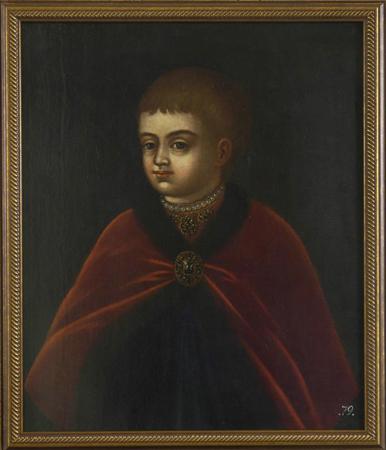
Also in 1682, a 10-year-old boy in Moscow called Piotr/Peter became “Tsar of all the Russias.” In its initial years, his tsardom was held jointly with a slightly older half-brother, Ivan, known to be of unsound mind, and effectively overseen by Ivan’s older sister Sophia. English-Wikipedia tells us this:
Sophia acted as regent during the minority of the sovereigns and exercised all power. For seven years, she ruled as an autocrat. A large hole was cut in the back of the dual-seated throne used by Ivan and Peter. Sophia would sit behind the throne and listen as Peter conversed with nobles, while feeding him information and giving him responses to questions and problems…
Peter was not particularly concerned that others ruled in his name. He engaged in such pastimes as shipbuilding and sailing, as well as mock battles with his toy army.
But “Great”-ness would lie ahead, for the boy and his large land-based empire.
The final thing worth noting this year was that, of course, the Spanish-colonial powers in the Americas continued to strengthen their presence. But in “New Spain”, they were still reeling from the large intifada that a large number of Pueblos had mounted two years earlier, which drove large numbers of (mainly armed) Spanish settlers, their priests (= mind-control agents), and their hangers-on out of a chunk of the SW of today’s United States. Thus in 1682, we saw the establishment or strengthening of these three replacement colonies to which the Spanish and their hangers-on had retreated:

- The Ysleta Mission, located in the Ysleta del Sur Pueblo within the municipality of today’s El Paso, Texas.
- The Nuestra Señora de la Concepción del Socorro mission, located south of today’s El Paso, and established specifically by the Franciscan monks who had played such a large role in attempting mind-control against the Pueblos.
- The village of Senecú (Senecú del Sur, San Antonio de Senecú) now located on the outskirts of Ciudad Juárez, Chihuahua, Mexico. It had originally been located north of the Rio Grande but its originally-Pueblo residents had fought against the also-displaced people in Ysleta, so they and their “village” got relocated.

Further south, off the coast of Venezuela, in 1683 the Spanish colonial powers built a massive fortification called Santa Rosa Castle on Margarita Island, after the island had been targeted by “French pirates.”
Yes, there was certainly still plenty of money in Spain’s sprawling imperial venture in the Americas to invest in a large-scale infrastructure project like this.
So about those French…
Here’s what English-WP has to say about the founding of Louisiana:
In 1660, France started a policy of expansion into the interior of North America from what is now eastern Canada. The objectives were to locate a Northwest Passage to China; to exploit the territory’s natural resources, such as fur and mineral ores; and to convert the native population to Catholicism. Fur traders began exploring the pays d’en haut (upper country around the Great Lakes) at the time… Priests founded missions, such as the Mission of Sault Sainte Marie in 1668. On May 17, 1673, Louis Jolliet and Jacques Marquette began the exploration of the Mississippi River, which they called the Sioux Tongo (the large river) or Michissipi. They reached the mouth of the Arkansas River, and then returned upstream, having learned that the great river ran toward the Gulf of Mexico, not toward the Pacific Ocean as they had presumed…
In 1682, René-Robert Cavelier and the Italian Henri de Tonti descended [presumably along the river] to the Mississippi River Delta. They left Fort Crèvecoeur on the Illinois River, accompanied by 23 Frenchmen and 18 Indians. They built Fort Prud’homme (later the city of Memphis) and claimed French sovereignty on the whole of the valley, which they called Louisiane in honor of the French king, Louis XIV. They sealed alliances with the Quapaw Indians. In April 1682, they arrived at the mouth of the Mississippi.
Cavelier eventually returned to Versailles, where he convinced the Minister of the Marine to grant the command of Louisiana to him. He claimed that Louisiana was close to New Spain by drawing a map showing the Mississippi as much farther west than it really was.

By the way, the banner image up above is a fanciful depiction of Cavelier declaring the establishment of Louisiana.
Also: Cavelier had the title “Sieur de la Salle” and is often referred to as “La Salle.”
His page on English-WP tells us this about what later happened to him and his grand colony-building ambitions for Louisiana:
On July 24, 1684, he departed France and returned to America with a large expedition designed to establish a French colony on the Gulf of Mexico, at the mouth of the Mississippi River. They had four ships and 300 colonists. The expedition was plagued by pirates, Natives defending their land, and poor navigation… They founded a settlement, near the bay which they called the Bay of Saint Louis, on Garcitas Creek in the vicinity of present-day Victoria, Texas. La Salle led a group eastward on foot on three occasions to try to locate the mouth of the Mississippi. In the meantime, the flagship La Belle, the only remaining ship, ran aground and sank into the mud, stranding the colony on the Texas coast.
During a final search for the Mississippi River in 1687, La Salle got lost and for “two years he wandered, without maps, in the marshes of the Mississippi delta”.
Some of his men mutinied, near the site of present Navasota, Texas.
On March 19, 1687, La Salle was slain by Pierre Duhaut during an ambush… One source states that Duhaut was a “disenchanted follower”. Duhaut was shot and killed by James Hiems to avenge La Salle. Over the following week, others were killed; confusion followed as to who killed whom.
The colony lasted only until 1688, when Karankawa-speaking Natives killed the 20 remaining adults and took five children as captives. Tonti sent out search missions in 1689 when he learned of the colonizers’ fate, but failed to find survivors.